The last time Dina came down from Benicia, I dragged her along on one of the usual hikes, Fremont Older. I figured the shorter hike would be best, since she normally walks on flat trails. It was a beautiful Sunday, and we managed to get up to Hunter's Point with fairly minimal whining (heh):


There was a very nice couple that passed us on the way up, and they offered to take our picture - Dina asked to have some vines in the background, but I don't think they're in this shot. As usual, we heard some gunfire from the nearby shooting range, and I practiced my "action movie zigzag run". You know, to avoid getting shot.

Ahem.

We also heard some peacocks - kinda scream-ish, kinda babies crying-ish.

All in all, a very satisfactory morning hike :)


Today we only had a few hours, so Roya suggested a hike she had done before with her mom, but driving closer, so we would get the "fun" part. So, off to Santa Teresa County Park we went. We took Almaden Expressway to the end, took a right at Harry, then a quick left on McClean. After about a half mile, we turned left on Fortini - it's a small residential street, blink and you'll miss it. Fortini dead-ends at the base of the hills, and there's a small parking area at the trailhead.

We got the beasts to stop wrassling in the back seat long enough to leash them up, and got started. The trail is all uphill at first, a rocky switchback path between bunches of bright orange poppies and other grassy plants. By the time you get to the top, you realize that it's not really the top (dammit!) and you keep going a bit more. The view is totally worth it:


 It was really a beautiful day - and we started early enough that it wasn't scorching. We kept on going, Roya quicker downhill than me:


Around this area, we briefly heard a rattlesnake - let's just say that properly motivated, we can BOOK.

At the bottom of this downhill section, there is a small wood bridge that goes over an even smaller stream - and right under the bridge, it's only a few inches of water, and a whole lot of mud. Of course Elliott started it - hops right off the bridge and starts nibbling on some plants. Then Koda decides to one-up Elliott, and hops right into the muddiest, wettest section, and LAYS DOWN. Roya and I were trying vainly to get both of them to get out of the mud, while hordes of bicyclists came hurdling down the hill toward the bridge. Luckily, they stopped to reminisce. (Or, you know, mock us from where they had a better view).

Ahem.

After the bridge, we went back uphill, then back down another hill, and the trail started heading to the right, then back in the general direction of where we parked. We stopped at pretty much the only shady section to see if the dogs would rinse themselves off, and sure enough, they were game:

 
We took a few minutes for the dogs to cool off, then got back on the trail. Just after this point, we actually saw two horses - Elliott was convinced they were giant dogs, and barked at them. Luckily, the horses were mellow and the riders were amused. A few minutes later, past a few rural yards and barking dogs, and we were back at the trailhead and civilization.


Ah, a sunny Friday! By law, you must leave work early, and so I did. Drove home, changed, grabbed the dog, and headed off to pick up Roya. We made it to the trail by 5:00, which gave us at least 2 hours of sunlight, and so decided to take the longer trail that had been closed until recently.

Phew.

I had forgotten just how much longer that trail is - and as the one who suggested it, I was not allowed to bitch (those are the rules). Roya however, had no such restriction, and there was quite a few "are we there yet?"s. I was right there with her.

For those of you who would like to follow our path, here's the trail map, with our path marked in red: 


On the way up, we took the Cora Older Trail until it connects to the Seven Springs Loop (Zero springs were seen by these hikers, although we were a bit loopy toward the end of the hike) We followed the Seven Springs Loop down the side of one hill, then back up the other, running into a fair amount of mountain bikers. We saw a good number of indicators that horses had also taken the same route, but I have yet to actually see a horse on any of the trails.

Since it's still spring, almost all the plant life is full and green, and there are wildflowers everywhere:


One of these days, I'll bring my Audubon wildlife book, and see what I can identify.

We came out from the Loop right below Hunter's Point, but neither me, Roya, or the dogs felt like scaling that hill. We decided to head downhill:


We made it back to the car by 6:30 - which, considering our fairly leisurely pace, was pretty damn good time.


I took the dog up to Fremont Older yesterday by myself, cuz Roya is getting ready for science camp (so jealous!). We did the usual hike - up the Cora Older trail, over to the Hayfield trail, and then up to Hunter's Point. It was a beautiful clear day, and you could see the whole bay area - awesome.

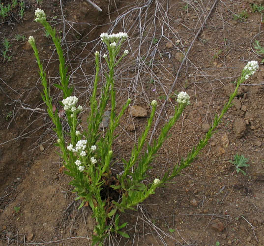
Elliott was being his usual crazy bunny-hopping self, and at one point, he found a patch of long fresh green grass, and laid down in it for a short rest. There were a ton of blooming wildflowers, and I'll mention one in particular: Gnaphalium californicum. Here's a picture:


Pretty ordinary, right? Well, in case you go hiking with your dog, and he or she tends to barrel through grasses and plants beside the trail, here's something to note. 

This plant makes your dog smell like maple syrup. 

Yup. 

I woke up this morning to my dog jumping on my bed, thinking that someone, somewhere was making pancakes. 

Seriously. 

Can I get a Hell Yea for Google, folks? :) 


Note to self - don't take long breaks from hiking.

This was not our fastest hike - sitting it out for a few weeks after hiking 3-4 times a week put us very close to back where we started - panting up the damn hill again. Grr.

But hey, we made it once again to Hunter's Point:


On our way down the hill, we passed the Monday hiking group, which now has morphed into a sort of "hike with your dog" group. Copycats.

(Also, on our way down, we heard some, uh, screaming. We're almost totally completely sure it was a peacock. We think. Or there's a crazy mountain people cult up there. But that's probably not what it was. It was for sure peacocks. probably.)

We took the Creekside trail back to Prospect Road this time - very pretty now that the mud has dried up. Anyway, it was a good segue back into the hiking habit, and we should be out again in a few days.


So - Roya has been sick, it's been raining, and I've been lazy. So, when Roya suggested we walk near Lake Almaden, I was totally in. And, judging by the pace we set, it was a good call.

I had never been to Lake Almaden before, just driven past it on Almaden Expressway on my way to other places (Hi, Bobby!).  We actually went to a trail that starts right at the end of Winfield drive and runs alongside Alamitos creek. The dogs enjoyed it in their own special ways: Elliott barked at all the dogs, and tried to catch all the squirrels and birds. Koda was far more well-behaved, only snarling at one puppy, and making us laugh by wading in the stream and coming out looking like a small gray alpaca.

heh. Koda the Alpaca. Still gets me every time :)

Google Maps says that our walk was 2.3 mile, and that feels about right - a good post-time change, after work beginning :)


Waiting for the weather to clear sucks when you're trying to start a hiking blog. And you know, actual hiking. The dog and I tried yesterday to walk through a field near my house, and as it turns out, fields generally get kinda muddy when it rains. And dogs get muddy when they wander muddy fields. Funny how that works... 

So yea, looking forward to actual trails, less mud.


Got a bit braver today, and tried a trail that I haven't been on in years, and that what I did remember about it was steep trails.

Yea, funny thing about memory - mine is pretty damned good, dammit.


Saint Joseph's Hill Open Space Preserve is great, because it is right in the middle of Los Gatos, but is still very wilderness-ish. It goes from Los Gatos, over the eponymous hill, and down again to Lexington Reservoir.

I planned this one, so did a bit of research on the best way to access the trails for an after-work hike, and found that the Novitiate Park would be the easiest for both parking and access. It's at the very end of Jones street (which is also the name of the trail) and there seemed to be plenty of on street parking, and I didn't see any signs for permits, so I felt OK leaving the car there.

The trail was muddy in places after yesterday's storm, but it wasn't impassable, and the dogs seemed to enjoy sniffing around through it. Also, the trail starts up right away on a slope - no easy flats to get you started. The first half mile alternated between decently steep grades, followed by easy slopes - it was timed just enough to get you panting, then give you a rest, then back to panting. At the one-mile mark, there is a nice place to rest and take in the view before the last bit of upward slope. Then comes the downhill trail to the reservoir - we debated about going, because we knew we'd have to come back up... Roya decided to let me decide, so we went for it.

At the bottom is the reservoir parking, with a few porta potties, but a lovely view of the reservoir:


And also, of Koda being adorable doing his high-five:


After we totally passed out from "teh Qte",. we turned to face the hill from the bottom. I suggested to Roya that we "climb that bitch like a ladder", but she wasn't buying it. So, up we trudged, thankfully encountering two older (and I gotta say, in awesome shape) ladies coming down the hill, who stopped to adore our dogs.

Yes, we totally used the cuteness of our dogs to put off a very steep hill. You'd totally do it too, don't lie.

Once we made it to the top of that hill, there was only a few rises before the trail turned completely downhill. Great for Roya, who has a well-trained, leash-led dog. Not so great for the tiny strong-man at the end of my leash. I finally had to hold the leash in one hand, and lead it behind my waist to keep Elliott from pulling me down into the mud with him. We made it to the bottom with only one small injury (I accidentally stepped on Ell's foot, but he was totally faking that squeal) and Roya pointed out that we managed about 3 miles of fairly challenging terrain in only an hour. WHOO, we are actually making progress!

Let's see how this next few days of rain go... maybe a weekend hike? :)


Since this was a normal workday Monday (wah) we went to Fremont Older again. We were a bit worried that it might be muddy after the rain, but the paths we took were mostly dry, so no major damage. Our pace is improving, although we still make stops here and there for the dogs (seriously. it's the dogs. we're not resting for ourselves. nope. not at all.). We made it up to Hunter's Point again, and Elliott was overcome with the romantic-ness of it all, and worked it out by humping Koda.

On our way down, we heard the shooting gallery again but I also heard a noise that sounded like a cross between a baby and a cat. I'm pretty sure it was a mountain lion, but I could be wrong. We also actually saw all kinds of animals this trip - a few bunnies jumping through the grasses, and about 6-10 deer grazing in a group on a hill. Luckily, it didn't seem like the dogs saw those animals.... However, they did manage to find the only other dogs in the park at the end of our hike, and Koda got so excited that he pulled away from Roya and ran straight to kill a Pomeranian puppy that was obviously thinking about killing us all. Thanks for saving us, Koda!!


Roya's last day off, and I manage to leave early again, due to another (!) 6:00 AM meeting with my East Coast peeps, yo.

Yea, I really can't pull that off, can I?

Anyway, since we got an earlier start, we decided to go further out, to Uvas Canyon County Park

(By the way, Uvas is Spanish for grape. However, I saw no grapes there. Way to go, namers.)

I had been here once before, when Elliott was much younger, but since I was by myself and it happened to be another rainy day, I didn't go far enough to really appreciate it.

The park is directly south of San Jose, and there are a few ways to get there. The first time I went, I took the 101 south, got off at the Bailey road exit, and turned left at McKean. This time,we went to the end of Almaden Expressway, and turned right on Harry, then left on McKean. Either way you get to McKeen, you'll be heading south for about 6 miles from Bailey road before you turn right on Croy. (Also, you won't notice, but McKean turns into Uvas road about halfway there). Once you are on Croy, you just drive. It's a pretty, curvy road, with horses and various yards to look at, and it slowly climbs until you're driving among trees. You'll know you're almost to the park when you get to Sveadal.


Sveadal is a private resort owned by the Swedish American Patriotic League, with adorable Swedish looking houses and decorations... Roya swears that it's where serial killers take kids to keep for a while before they kill them.

I say Tomatoe, You say grisly site for holding children. Moving on.

So, drive nice and slow through Sveadal, and just at the end of the resort, the road will curve to the left, and Voila!

The parking lot was mostly empty, since rain was predicted for the day, but at the time we got there, it was actually blue skies with a few clouds. The dogs were pumped, so we got them out of the back seat (more humping) and Koda decided to celebrate right away by laying a fresh one on the pavement. Koda never stands on circumstance :)

We scooped up (of course!) and got the dogs moving generally in the direction of the trail, stopping to see if there was a "You are here" thingy on the map. There wasn't, but we managed to find ourselves after all. We waved, and started for the Waterfall Loop.

Yes, you heard it - WATERFALL. This place has a bunch of really lovely waterfalls. They're not Niagara in scale, but the setting they're in is so beautiful, and they're all so accessible, that their smaller size is not even an issue. For example:


And that's just one. The waterfall loop trail we took had 3 major falls (Black Rock, Basin, and Upper Falls) and there were smaller water features everywhere. We got rained on a bit, but neither us nor the dogs had any problem at all with it. 
We'll definitely come back to this park.


On Roya's week off, I was able to get out of work early, since I was forced to come in early for a meeting on east coast time (GRRR). It worked out well, though, since we got plenty of time to get to the Fremont Older Open Space Preserve

The drive to the preserve is a pretty one - once you get off the 85 at De Anza, you head south towards Saratoga, but then make a right at Prospect. After a left at the stop sign to stay on Prospect, the road wanders past a few country clubs, and a bunch of big houses. The road is curvy, so you have to drive slow, but the scenery is worth your patience. After the Saratoga Country club, turn left, and the road narrows as it passes more homes, then widens at a small parking lot. I've almost always found a spot when I needed to, but supposedly during peak times, it fills up quick.

So, we gathered the dogs (Elliott was busy humping Koda in the back seat) and got them on their leashes. We walked over to the head of the trail, then back, because I forgot the poo bags. The trail started on an incline up the side of the first hill, and we got started slowly, the dogs sniffing everything in site. Once we get going, the pattern that repeats through the hike begins - Elliott rushes ahead, sniffing madly on either side of the trail, and Koda pants and tries to catch up to Elliott. They're really pretty ridiculous.

We get to the top of the first hill, and stop to catch our breath and give the dogs some water - Elliott crowds Koda out of the way, takes a few slurps, then wanders off, and Koda finishes most of the water. Roya dumps the rest of the water on Koda's head, which does not amuse him AT ALL.

I wanted to go on the hike that goes down into a canyon, then back up the hill, but it seems to be closed (I read later that there were some reconfiguring of the trail, and they closed it for "settling"). We go left instead, up towards Hunter's Point.

I point out our goal to Roya and she says "It doesn't look that bad". Heh.

We make it up to Hunter's Point, and sit down on the bench to catch our breath. On the way up, I kept hearing popping noises, and a man that was already at the top told us that there is a shooting club nearby. I'm just hoping no one aims in our direction...


We head back down, me with both dogs pulling me like I'm on the tundra, and Roya trying to keep from sliding, and we make it back to the car with no major mishaps. All told, this fairly easy hike lasted about an hour and a half.